Showing posts sorted by date for query Khyber. Sort by relevance Show all posts

Friday, 17 June 2011

Lowari Pass Chitral pakistan

Lowari Pass

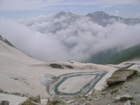
Lowari Pass (or Lowari Top) (el. 10,230 ft.) is a high mountain pass that connects Chitral with Dir in Khyber-Pakhtunkhwa, Pakistan. Lowari Top is a relatively low pass, by far the lowest pass to enter Chitral, the rest all being 12,000 to 15,000 feet.


Lowari Top is closed by snow from late November to late May every year. During this time, jeeps cannot cross so men must travel by foot. This is dangerous, as there are high mountains on each side of Lowari Top, and a deadly avalanche can come at any moment without warning.
Every winter a few persons are killed by avalanches while crossing Lowari Top. Their bodies are buried under the snow and it is only when the summer comes and the snow melts that their bodies are found and their fate learned.
Nevertheless, Lowari Top remains popular because it is the shortest route from Chitral to Peshawar. The other way would be down the Kunar River to Jalalabad through hostile Afghan Territory or the much longer route across Shandur Top to Gilgit.


Lowari Top crosses the Hindu Raj Mountains, a spur of the higher Hindu Kush. On the Chitral side of Lowari Top are the people of Ashret, who speak the Phalura language and were assigned by the Mehtar of Chitral to be the guardians of Lowari Top.
On the Dir side reside Gujjars, some of whom make their living as porters carrying loads across Lowari Top.
In 1954, the Mehtar of Chitral was killed when his airplane crashed into Lowari Top. Even today, PIA pilots often turn back because of winds and fear of crossing Lowari Top.
The word "Top" is believed not to be the English word "top" but a word from an ancient language no longer spoken there.
The Lowari Top is one of the four major mountain passes to enter Chitral. The others are the Dorah Pass from Badakshan in Afghanistan, Shandur Top from Gilgit, and Broghol from the Wakhan Corridor in Afghanistan.
The Lowari Tunnel is currently being constructed beneath Lowari Pass by a Korean company. The tunnel is expected to be fully open in 2012.

Wednesday, 15 June 2011

Bolan Pass Blochistan Pakistan

Bolan Pass

The Bolan Pass is a mountain pass through the Toba Kakar Range of Balochistan province in western Pakistan, 120 kilometres from the Afghanistan border.
Strategically located, traders, invaders, and nomadic tribes have also used it as a gateway to and from the South Asia.[1] The Bolan Pass is an important pass on the Baluch frontier, connecting Jacobabad and Sibi with Quetta, which has always occupied an important place in the history of British campaigns in Afghanistan.
Traditionally, the Brahui of the Kurd tribe are in charge of the law and order situation through the Pass area. This tribe is still living in present day Balochistan in Pakistan.
In 1837, threatened by a possible Russian invasion of South Asia via the Khyber and Bolan Passes, a British envoy was sent to Kabul to gain support of the Emir, Dost Mohammed. In February 1839, the British Army under Sir John Keane took 12,000 men through the Bolan Pass and entered Kandahar, which the Afghan Princes had abandoned; from there they would go on to attack and overthrow Ghazni.
In 1883, Sir Robert Groves Sandeman negotiated with the Khan of Kalat Khudadad Khan and secured British control over the pass in exchange for an annual fee.


Bolan Pass railway

From Sibi the line runs south-west, skirting the hills to Rindli, and originally followed the course of the Bolan stream to its head on the plateau. The destructive action of floods, however, led to the abandonment of this alignment, and the railway now follows the Mashkaf valley (which debouches into the plains close to Sibi), and is carried from near the head of the Mashkaf to a junction with the Bolan at Machh. An alternative route from Sibi to Quetta was found in the Harnai valley to the N.E. of Sibi, the line starting in exactly the opposite direction to that of the Bolan and entering the hills at Nari. The Harnai route, although longer, is the one adopted for all ordinary traffic, the Bolan loop being reserved for emergencies. At the Khundilani gorge of the Bolan route conglomerate cliffs enclose the valley rising to a height of 800 ft., and at Sir-i-Bolan the passage between the limestone rocks hardly admits of three persons riding abreast. The temperature of the pass in summer is very high, whereas in winter, near its head, the cold is extreme, and the ice-cold wind rushing down the narrow outlet becomes destructive to life. Since 1877, when the Quetta agency was founded, the freedom of the pass from plundering bands of Baluch marauders (chiefly Marris) had been secured by the British Indian Army.


Thursday, 9 June 2011

Khyber Pass Pakistan

Khyber Pass

The Khyber Pass, (Pashto: د خیبر درہ, Urdu: درۂ خیبر) (altitude: 1,070 m or 3,510 ft) is a mountain pass linking Pakistan and Afghanistan.
The Pass was an integral part of the ancient Silk Road and throughout history, it has been an important trade route between Central Asia and South Asia and a strategic military location. The summit of the Khyber Pass is 5 kilometres (3.1 mi) inside Pakistan at Landi Kotal and it cuts through the northeastern part of the Safed Koh mountains which themselves are a far southeastern extension of the Hindu Kush range.


Origin of Name

According to historians and local oral traditions, Khyber is a word of Hebrew origin meaning a fort, castle or palace.
"Khyber is a Hebrew word, it means a fort". [1] [2]
"No one knows when Khyber got its present name, but this much is certain that "Khyber" is a word of Hebrew language and it means palace or castle. There is also a city and fort known as "Khaybar" Forty miles to the west of Medina (Saudi Arabia), which was inhabited by Jews before the rise of Islam, and was conquered by Muhammad in 629 AD..".


History

In some versions of the Aryan migration theory, the Indo-Aryans migrated to India via the Khyber Pass.[citation needed] Recorded invasions through the Khyber begin with the conquests of Darius I and Alexander the Great and also include later Muslim invasions of South Asia, culminating with the establishment of the Mughul Empire from 1526. The British invaded Afghanistan from India and fought three Afghan Wars in 1839-42, 1878-80, and 1919. George Molesworth, a member of the British force of 1919, summarised: "Every stone in the Khyber has been soaked in blood." Rudyard Kipling called it "a sword cut through the mountains."
Finally, Sikhs under Ranjit Singh, in 1798 brought to an end the 800 years of foreign invasions into India through Khyber Pass, by bringing it under their control. This was the best gift the Sikhs gave to the nation which finally allowed the rest of India to breathe in peace. Hari Singh Nalwa, who manned the Khyber pass for years became a household name in Afghanistan.
Afghan chiefs and a British Political officer posed at Jamrud fort at the mouth of the Khyber Pass in 1878.
To the north of the Khyber Pass lies the country of the Mullagori tribe. To the south is Afridi Tirah, while the inhabitants of villages in the Pass itself are Afridi clansmen. Throughout the centuries the Pashtun clans, particularly the Afridis and the Afghan Shinwaris, have regarded the Pass as their own preserve and have levied a toll on travellers for safe conduct. Since this has long been their main source of income, resistance to challenges to the Shinwaris' authority has often been fierce.
For strategic reasons, after the First World War the British built a heavily engineered railway through the Pass. The Khyber Pass Railway from Jamrud, near Peshawar, to the Afghan border near Landi Kotal was opened in 1925.
During World War II concrete "dragon’s teeth" (tank obstacles) were erected on the valley floor due to British fears of a German tank invasion of India.[4]
The Pass became widely known to thousands of Westerners and Japanese who travelled it in the days of the Hippie trail, taking a bus or car from Kabul to the Afghan border. At the Pakistani frontier post, travellers were advised not to wander away from the road, as the location was then a barely controlled Federally Administered Tribal Area. Then, after customs formalities, a quick daylight drive through the Pass was made. Monuments left by British Army units, as well as hillside forts, could be viewed from the highway.
The area of the Khyber Pass has been connected with a counterfeit arms industry, making various types of weapons known to gun collectors as Khyber Pass Copies, using local steel and blacksmiths' forges.[5][6]


Current conflicts

During the current war in Afghanistan, the Khyber Pass has been a major route for resupplying NATO forces in the Afghan theater of conflict. Recognizing this, the Taliban attempted to choke off the route in late 2008 and early 2009, bringing the Taliban into conflict with the Pakistani government.[7]
In February 2009, a bridge 15 miles northwest of Peshawar was blown up by militants presumably sympathetic to or sponsored by the Taliban. While it was not considered to be a major strategic blow to the allied war effort, it invigorated efforts to secure additional supply routes, some of which may ultimately run through Iran. However, the current general consensus is that the new supply route will pass through various central Asian republics to the north of Afghanistan.

Thursday, 26 May 2011

Ansoo Lake Pakistan

Ansoo Lake

Ansoo Lake is a high-altitude lake (elevation 16,492 feet or 5,027 metres) in the Kaghan Valley in the Mansehra District of the Khyber-Pakhtunkhwa province of Pakistan. It is near Malika Parbat in the Himalayan range.
This lake can be reached by two different routes. First one is short but steeper trek from Saiful Mulook Lake. It takes more than 12 hours for a round trip to Ansoo lake starting from lake Saiful Mulook. The trek is covered with snow in most parts of the year. The best time to trek is from July 10 to August 15. The optimal time to set off for the lake from Saiful Mulook is around 06:00 in the morning. Horses can also be hired from the Lake Saiful Mulook along with a guide who will take you to Ansoo Lake. It costs almost PKR 1200-1500 per horse and PKR 1000 additional for the guide but one still has to walk more than 35% of the distance by himself. This trek can be further divided into two part. First half, which is towards Saiful Malook, is valley along the river and it goes up to Malika Parbat base camp. Second half is steeper starting from Malika Parbat base camp and ends with Ansoo Lake. This part is all about climbing on the mountain.


Second trek to reach Ansoo Lake starts from the village Mahandri, which is 40 km south to Naran Village, and it goes through Manoor Gali and Kach Gali. This trek takes at least three days of 12 hour trekking to get to Ansoo Lake. Steepness of this trek may be the same as of other one but travel in the valley is lot more. This gives an opportunity to camp along the rivers, in jungles, on the top of mountains and in abandoned towns.
Both of above mentioned treks run in opposite direction from Ansoo lake and are connected via mountains top forming half circle 300–400 feet above the lake waters. From this altitude, there is an amazing vista of lake on one side and top of Malika Parbat and beautiful skyline of high altitude mountains covered with snow on the other side. There is no risk free way to reach lake waters because it lies in the crater with steep, snow covered walls. There is no apparent drainage of lake water and no one ever tried to explore it because of its dangerous approach and limited resources in that area.
The name "Ansoo" comes from its tear-like shape (the Urdu word Ansoo means teardrop). This lake also resembles Human Eye with central ice land resembling Iris of Human Eye and a ridge resembling Eyebrow becoming even more prominent when ice melts on the Eyebrow in summers. This ridge was partially destroyed in 2005 Kashmir earthquake.
The lake is said to have been discovered in 1993 by Pakistan Air Force Pilots who were flying low in this area. Earlier, the lake was not even known to the locals.[citation needed]
There is no place to stay at Ansoo Lake. Some people may camp on the top of extremely cold and windy mountains at their own risk.