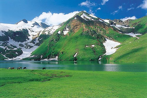
Saturday 30 April 2011

SHAHRAH-E-RESHAM

SHAHRAH-E-RESHAM


Battagram (Urdu: ضلع بٹگرام) is a district of Hazara in the Khyber Pakhtunkhwa province of Pakistan. It has a total land area of 1301 square kilometres and the estimated population of Battagram District in 2004-2005 was 361,000. The main language of the district is Pashto.


This district is noted for its scenic mountain scenery, thick forests, fertile lands and enchanting streams. Most of the population is rural and depends upon agriculture for their day to day living. As a recent phenomenon, fishing has also become a mode of earning due to some modern scientific techniques. Another distinctive feature of this district is the notable presence of Shahrah-e-Resham (Karakoram Highway) or Silk route and hence which is helping the infant industrial base to thrive.

Friday 29 April 2011

MALIKA PERBAT

Malika Parbat


Malika Parbat (Queen of the mountains) (el. 5,290 metres (17,356 ft)) is the highest peak in Kaghan Valley, Khyber Pakhtunkhwa, Pakistan about six km south of Lake Saiful Muluk near Ansoo Lake.\

Thursday 28 April 2011

KALAM PAKISTAN

Kalam 

Kalam Valley is a valley along the upper reaches of the Swat River in Swat, in the Khyber Pakhtunkhwa province of Pakistan.


Kalam Valley is known for its waterfalls, lakes and lush green hills, and is a 270 km drive from Islamabad, the capital of Pakistan. It is a popular destination for tourists.

At 29 kilometres (18 mi) from Bahrain and about 2,000 meters (6,800 ft) above sea level, the valley opens out, providing rooms for a small but fertile plateau above the river. In Kalam the Ushu and Utrot rivers join to form the Swat River. Here, the metalled road ends and shingle road leads to the Ushu and Utrot valleys. From Matiltan one gets a breathtaking view of the snow-capped Mount Falaksir 5918 meters (19,415 ft), and of another unnamed peak 6096 meters (20,000 ft.) high.


Wednesday 27 April 2011

Naran Pakistan

Naran Valley


Naran Valley (Urdu: وادی ناران) is located in Khyber-Pakhtunkhwa, Pakistan. The Kunhar River, swollen by glacier melt, meanders its way through the Naran Valley. Makra Peak, Malka Parbat, Lalazar and Saiful Muluk are the main attractions.[citation needed]

Tuesday 26 April 2011

Kaghan Valley Pakistan

Kaghan


The Kaghan Valley (Urdu: وادی کاغان) is a valley in the north-east of Mansehra District of the Khyber-Pakhtunkhwa Province of Pakistan. It attracts many tourists from around the country. The inhabitants were affected by the earthquake disaster on 8 October 2005.

The Kaghan valley is named after the town of Kaghan rather than for the Kunhar River which flows through the length of the valley. The valley extends 155 km, rising from an elevation of 2,134 feet (650 m) to its highest point, the Babusar Pass, at 13,690 feet (4,170 m). Popular languages are Hindko and Gojri, while Urdu, Pakistan's national language is also familiar among the locals. The region is Alpine in geography and climate, with forests and meadows dominating the landscape below peaks that reach over 17,000 feet.


Tourism

Its mountains, dales, lakes, water-falls, streams and glaciers are still in a pristine state. Kaghan is at its best during summer (from May to September). In May the temperature ranges between a maximum of 11 °C (52 °F) and a minimum of 3 °C (37 °F). From the middle of July up to the end of September the road beyond Naran Valley is open right up to Babusar Pass. Movement is restricted during the monsoon and winter seasons. The Kaghan area can be reached by road via the towns of Balakot, Abbottabad and Mansehra. In Balakot, one may find buses and other transports to reach Kaghan or Naran Village.
The road from Balakot ascends along the Kunhar River through lovely forests and the villages of Paras, Shinu, Jared and Mahandri. The valley is somewhat narrow along this stretch and the views are limited but as you ascend, the surrounding peaks come into view. One spot that is quite famous for its spectacular view and scenery is 'Shogran'. This village, surrounded by peaks and forests, is east of the main Kunhar River. It hosts the famous Siri Payee Lake mountain with breathtaking views at its top.


Monday 25 April 2011

Chagi Balochistan, Pakistan

Chagai 


Chaghi/Chagai is the largest district of Pakistan and is located on the north west corner of Balochistan, Pakistan.[1] It forms a triangular border with Afghanistan and Iran. Pakistan conducted a nuclear weapons test in 1998 at Ras Koh Hills Chagai District.